
Updates from the Council Municipal Airport
There has been a lot of activity lately at the Council Municipal/Clint Yates Field, otherwise known as the Council Airport. On February 26, a Pilates PC-24 jet flew in from Oregon and landed at the airport, transporting executives who were visiting the local lumber mill. Three days later OrePac Building Products announced their purchase of Western Timber Products. The arrival of a jet caught the attention of a number of local residents! Jets normally require a runway of at least 5,000 feet (the Council Airport is 3,600 feet long) but this version of a Pilatus jet only needs 3,000 feet to land.
Since January two different helicopter companies have been contracted by mining companies with claims near Cuddy Mountain and have been flying out of the Council Airport to stake out the claims. The helicopters are normally based in McCall or Lewiston but Council is a much closer and more convenient location for these operations. Since the helicopters require jet fuel instead of the aviation gas the airport has in its fuel tank, the companies have staged a fuel truck at the airport and pay the City fuel flowage fees to offset the use of the airport.
For a little background, the airport was built in 1948 in the Village of Council and was a 2,100-foot-long gravel airstrip. In the late 1970’s a new runway was built after relocating Orchard Road. The airport was renamed in 2001 in honor of Clint Yates who ran the Council Air Service for many years and was a significant advocate for local aviation. A more complete history of the airport will be submitted for publication in the paper later this year.
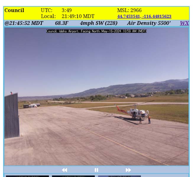
Two years ago, $6,500 was donated by a number of supporters, to include LifeFlight, to install three cameras and a weather system at the airport for pilots to monitor the local weather so they can safely takeoff and land. The cameras look north and south along the runway and also to the northwest where many pilots fly in from Oregon before going into the Idaho backcountry airstrips. The weather system records the wind, temperature, rainfall, humidity and barometric pressure (altimeter setting) that the pilot dials into the airplane’s altimeter to adjust for varying air pressure and ensure an accurate height on the altimeter. The website with the weather camera is available to the public and can be found online at https://map.eye-n-sky.net/SitePages/Council. On the bottom of each camera view a forward arrow button will show a 24-hour loop of still photos taken every 15-minutes. Unfortunately, the cameras shut down at night so they did not capture the recent Aurora Borealis show! Also on each of the camera views is a hyperlink on the upper right corner “WX” that links the user to the weather page. Weather information is also collected by the manometer on the field.
In 2022 a contest was held to design a logo for use in promoting the airport and the local community. Curtis Crothers from Fruitvale submitted the winning design featuring an airplane taking off to the south, the Weiser River Trail, and Council Mountain in the background. This airport truly is the best stop before the backcountry!
Through other donations from the Idaho Aviation Association a 1998 Dodge Durango courtesy car is available for pilots to use to get into town to shop or eat, conspicuously labeled “Council Airport Courtesy Car.” A bike shed was donated by AeroLed and the Mesa Shed Company that houses four donated mountain bikes pilots can also use to get into town or ride on the trail.
With these new airport amenities, pilots are visiting the airport and our local area more often. In April two separate groups held fly-ins to have breakfast at local restaurants and to visit some of the stores to include Carter Cutlery and Council Guns. Businesses are welcome to post flyers or menus at the Chamber of Commerce’s kiosk by the fuel tank to entice pilots to visit.
The Council Municipal/Clint Yates Field is a wonderful resource for the community, encouraging visitors, supporting businesses, providing a safe place for medical evacuation and firefighting operations when needed. The airport is owned by the City of Council but is mostly funded through Federal and State grants that are paid for through aviation fuel taxes, and also by hangar owners through land-lease agreements and property taxes.
There is an upcoming event planned at the airport on June 1, 2024 called a Short Takeoff and Landing (STOL) clinic. Up to 25 airplanes will arrive by 8:00 a.m., breakfast will be served and a safety brief will be given at 9:00 a.m. before the pilots take off to practice short takeoffs and landings before the snow melts in the mountains and summer flying ramps up. STOL flying will continue until early afternoon. Temporary markings will be painted on the runway to simulate a 25-foot wide by 800-foot long landing area, very similar to the size of the landing areas of a number of backcountry airstrips found throughout Idaho. The public is invited and encouraged to come see the planes, talk with the pilots and watch the flying! Anyone interested in volunteering or who wants further information can email u82manager@gmail.com.